Lesson Objectives
- Understand the complex exhisting conditions in the Sahel Region
- Explain how climate change will directly and indriectly impact this region
The Sahel region of North Africa can be regarding as one of the most complex systems on Earth. It has both a very complex and diverse population and complex and fragile climate. This elements combined create a region of very high vulnerability both environmentally and socially to any kind of hazard. At present these hazards are being severely enhanced by the impact of anthropogenic climate change.
In 2008 the UN’s chief advisor referred to the Sahel region of West Africa as “ground zero” for vulnerable communities struggling to with climate change.
To review the impacts of climate change the UN have developed a framework that covers the hazard, vulnerability and capacity to cope.
 Added to this the UN considers five main areas than can further enhance and be affected by climate change. These are:
- Vulnerability Climate change threatens food security and human health, and increases human exposure to extreme events.
- Development If climate change slows down or reverses the development process, the resulting increased vulnerability may undermine the capacity of States to maintain stability.
- Coping and security: Migration, competition over natural resources, and other coping responses of households and communities faced with climate-related threats could increase the risk of domestic conflict.
- Statelessness: There are implications for rights, security, and sovereignty of the loss of statehood because of the disappearance of territory.
- International conflict: The impact of climate change on shared or un-demarcated international resources may affect international cooperation.
In order to understand the risk and consequences of climate change it is first important to grasp the complex genetics of this region. This section will review the physical and human geography of the area.
Physical Geography
The Sahel refers to the area of Africa lying between 12°N and 20°N. This area shares two climatic characteristics: one rainy season per year and August as the month of highest precipitation.
 The Arabic word sahel (“shore”) denotes the transition zone between the Sahara Desert to the north and the savannah plains to the south. It is a semiarid region with an average rainfall between 12 to 20 inches per year. Since the definition of the Sahel is based on climate, it does not abide by strict international borders.
The area covers all or part of 12 countries from the Atlantic coast to the Red Sea: Mauritania, Senegal, The Gambia, Mali, Burkina Faso, Niger, Nigeria, Chad, Sudan, Ethiopia, Eritrea and Djibouti. These countries span an area over 7million square kilometres
Few other places share the same climate variability that characterises this region, even when compared on very different time-scales. It is characterized by the strong seasonality of the climate with a short rainy season and a long intensely dry season. Its limits are not readily definable. Conditions in the zone vary markedly from north to south with rainfall, and also over short and long periods of time as the rainfall varies. The long term variations in climate have left a strong impress on the landscape and soils of the region. It is a harsh environment.
Population Dynamics
The population of sub-Saharan Africa, estimated at 920 million in mid-2014, will more than double in the next 36 years. These projected demographic changes will have tremendous consequences for many issues, from agricultural production to prospects for socioeconomic development, as well as for the political stability of many countries. The Sahel, in particular, will face the most extreme challenges, compounded by the threat of the Al-Qaeda in the Islamic Maghreb.
The region’s GDP per capita in purchasing power parity is relatively low, ranging from approximately US$900 to less than US$3,000 per capita, with the only significant income coming from natural resources like oil and minerals. The World Bank’s 2015 Doing Business report ranks these nations among the least business-friendly, due in large part to their history of political instability. Moreover, the World Bank lists half of the nations of the Sahel as fragile states (low-income countries with weak state capacity).
Significant population growth appears to be the strongest force driving the region’s potentially turbulent future. With annual demographic growth rates ranging from 2.5 percent to nearly 4 percent, the population will continue to grow beyond the region’s capacity. This growth has occurred because of commendable rapid decreases in infant and child mortality but lagging decreases in fertility. Fertility rates vary between 4.1 and 7.6 children per woman on average.
The age structure of the countries of the Sahel will remain predominately young. The number of youth (those younger than 20) is likely to double by 2050. Niger will have the highest youth dependency ratio (ratio of those younger than 20, or dependents, to those ages 20 to 64, or working age) for the next 36 years. Even in 2050, Niger will have 132 people younger than 20 for every 100 people ages 20 to 64. The demographic dividend that could be gained from a larger workforce (when relatively more working adults support relatively fewer dependents) appears to be decades away for the majority of the countries of the Sahel.
Resource Availability
Water Security
Less than half the population of the Sahel has access to water while its demand increases with rapid population growth. The resultant threat to health and livelihoods is set to become worse with desertification likely to increase by 5–8% by the 2080s. As the climate becomes more variable, the dichotomy of water stress and water abundance become more apparent; when it rains here it can fall with such force, and be so intensively localised, that it can destroy crops and cause flooding. Managing this water dichotomy has to be part of the solution; ‘good’ rainfall and ‘bad’ rainfall years necessitate water management to reduce shortfalls.
Food Security
When the Sahel is in the news, it is often because millions of people are at risk of going hungry. A humanitarian crisis usually unfolds on the back of a food crisis. Over the past five decades, persistent droughts have contributed to famine episodes. There is now a need to break the cycle of recurrent food crises in the region, many humanitarian actors say.
Food security dynamics in the Sahel have evolved greatly over the last decades. Today, rainfall is only one of several factors in determining food insecurity. Food production, i.e. food availability (highly dependent on rainfall characteristics), combines with other factors such as malnutrition, access to food, and market and trade mechanisms in determining food insecurity. Widespread malnutrition, particularly of children, increases vulnerability and the health impact of food shortages. Access to food depends on physical criteria like infrastructure but also on financial, such as prices for marketed food-products. In addition, market mechanisms can amplify the fluctuations of production through price levels and trading strategies.
Employment
At least 95% of the food production in the Sahel is based on rain-fed agriculture. The agricultural sector employs, directly or indirectly, more than half of the Sahel’s population. Many of these are small scale subsistence farmers wither with a fixed abode or nomadic.
Climate change and the Sahel
These issues above just touch on the complex tapestry that is the Sahel region of Africa. Many take the opinion that climate change impacts will be felt most strongly in this region both as a result of the hazard (the magnitude and frequency of the changing conditions) and the vulnerability (pre-existing human conditions and capacity to adapt and mitigate.)
Direct Consequences of Climate change
Precipitation
Precipitation is one of the most complex variables to grasp when reviewing the impacts of climate change in the Sahel. Overall the region is receiving less rainfall in total however some parts are receiving a big increase. This is due to shifting pressure gradients and air masses controlled by temperature change. Much of the coastal areas are receiving more rainfall due to more ocean evaporation. The interior on the other hand is receiving less rainfall and the rise in temperature is causing increased evaporation removing what little moisture was available. 
The following map summaries the changes in precipitation from 1970-2010.
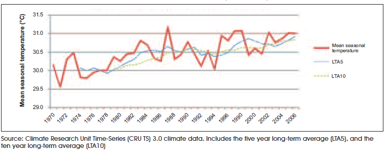
 Temperature
Over the whole area the average temperature increase has been 1.0 degree. However due to the large areal extent of the study zone the actual rate of increase varies from 3.0 in the middle of the area to 0.5 degrees of warming. The main controlling factor behind this variation is cooling impact of the sea/ coast.
 The following map depicts these changes.
 Indirect Consequences of Climate Change
Water Availability (drought)
The region has experienced three major drought periods during the last century: 1910-1916, 1941-1945 and a longer period starting in the 1970s, which can be considered to be still ongoing despite some interruptions due to one-off seasons with adequate rainfall. Large areas of Chad, Mali, Mauritania and Niger faced between six and ten drought seasons between 1982 and 2009, with smaller pockets experiencing between 11 and 15.

Lake Chad –Case Study
Since 1963, Lake Chad has contracted by 90 percent, down to 1,350 km2 from its original size of 25,000 km2. In addition to changing climatic conditions, resource misuse and overuse as well as population growth explain this massive contraction. Between 1983 and 1994, the volumes of water used for irrigation were four times larger than during the previous 25 years. The population in the region furthermore increased from 13 million in 1960 to more than 35 million in 2007, and is expected to continue to grow by another 75 percent by 2025 .These changes have impacted both aquatic and terrestrial ecosystems, and the quantity and quality of available freshwater.
 As a result, water scarcity, health issues, food insecurity and poverty have increased dramatically in the area. Due to the lack of freshwater, water-related diseases like diarrhoea, cholera and typhoid have become common. Populations not directly dependent on natural resources for their livelihood have also been affected, This region, which is home to over 300 ethnic groups, as well as migrant workers from other African countries, such as Burkina Faso and Ghana, has seen heightened tensions over water access between different communities and livelihood groups resulting in both migration and increasing territorial disputes . According to a recent study, the shrinking of Lake Chad has contributed to conflicts in two notable ways: “First, by intensifying the frequency of contact between and among the major livelihood systems, thereby making them more competitive rather than complementary. Second, it intensifies the pattern of migration as a response to the contraction of the lake.
Flooding
Flooding in the region can be associated with two difference causes. Sea level rise due to melting glaciers and thermal expansion is affecting coastal communities. In addition the precipitation the region is receiving is now more commonly arriving in short duration high intensity events. These result in flooding due to impermeable soils baked hard by the sun. The intensity means that the permeable soils are then unable to cope with the infiltration. One upshot of this is ruined crop yields.
 Case study: Flooding and migration in Ghana
In August 2007, Ghana experienced unprecedented flooding that devastated the nation’s crops and infrastructure and led to the displacement of over 330,000 people, as well as the death of 56. The damage occurred primarily in the three northern regions of the country, where a substantial portion of the nation’s crops are grown.
Food Security
Agricultural production and food security are particularly sensitive to climate variability. Climate change impacts are expected to further increase vulnerability. The combination of poor quality soil, increased aridity and flooding have all combined to result in very low food security. In 2012, the lives of up to 18 million people were put at risk following a major food crisis in the region. This year, more than 11 million are facing the same plight, while 1.4 million children are threatened with severe malnutrition. Even in normal years, millions are in a permanent state of food insecurity. In Burkina Faso in late May, as they waited anxiously for the next crop, more than 330,000 people faced food insecurity. In Gnagna province, with an average of seven people in each household, the situation is far worse than in the rest of the country. Farmers are producing less than half the food they need to survive. After four to six months their reserves run out. In the worst years, they have no option but to sell part or all of their livestock – if they have any – or run up debts.
Conflict / Political Instability
The potential impacts of climate change on conflict have received considerable attention since the publication of IPCC Fourth Assessment Report in 2007. With respect to Africa, Burke et al. (2009) concluded that civil wars were more common in Africa in warmer years, and went so far as to quantify the impacts of climate change on conflict, suggesting a climate-related increase in the incidence of armed conflict of 54% by 2030, resulting in an additional 393,000 deaths.
A report by UNEP (2007) linked the conflict in Darfur to climate change, desertification and land degradation, arguing that these factors had brought farmers and herders into conflict over dwindling resources.
The changing climatic conditions are resulting in greater migration of nomadic communities. These communities are being pushed further and further south in the search for pasture for the livestock which is seeing them come into increasing conflict with settled dwellers and other nomadic communities.
Migration
Many in the developed world see the greatest long term threat of climate change coming from the enormous number of displaced migrants. The world is already seeing unprecedented numbers of migrants fleeing North Africa either as a result of persecution or the pull of a better life in Europe.
The trends observed over the last 40 years show that overall in the region covered in this report, temperatures have risen, droughts have been recurrent and severe, rainfall has generally increased, and floods have occurred more frequently and with more intensity. These changes, in turn, have already impacted livelihoods in the region by increasing vulnerability and affecting the availability of natural resources.
In the Sahel, the traditional temporary and seasonal migration patterns of many farmers, herders and fishermen in the region are increasingly being replaced by a more permanent shift southward and to urban areas. Nearly half of the West African population now lives in largely overcrowded coastal cities, including 12 townships of over one million inhabitants along the coastline from Senegal to Nigeria.
Whilst at present the majority of the migration trend is internal migration within the Sahel region many fear the longer term impacts could be international.
The following graphs sums up a report into the motivations for migration within the Sahel region and food security which is heavily linked with climate change featured highly.

Further Reading
